Washington State Route 530 (SR 530) runs east from Interstate 5 (I-5) through Arlington, to Darrington, where it turns north to Rockport. The highway extends 28 miles east, into the fir clad mountains that hold Darrington and the Sauk Prairie, and from there, 19 miles along the Sauk River to the Skagit River valley and Rockport. The stretch from I-5, across north-south SR 9 to Arlington is described in the first post in this series, State Route 530. The section of the roadway from Arlington past the Cicero Bridge is traveled in the second post in the series, State Route 530 – Part 2.
This post follows the highway from the Cicero Bridge east to Darrington, home of one of the Hampton Lumber Mills, a distance of 20 miles. Along the way, SR 530 passes the community of Oso, the Oso Slide Memorial and the vanished community of Hazel, the ghost of Fortson Mill, the Darrington Rodeo Grounds, and the Darrington Bluegrass Park.

In the image above, snow-dusted Prairie Mountain has its head in the clouds as it looks down on Sauk Prairie and the Hampton Lumber Mills in the town of Darrington. This shot of the lumber mill is on the east side of State Route 530, at the north edge of Darrington.
Oso
Oso is a census designated place in Snohomish County, Washington. The 2019 population was 326. Single family homes, many of which are decades old, and small farms, some passed through several generations, are scattered between and along State Route 530 and the North Fork of the Stillaguamish River.
In addition to the scattered homes and farms near the confluence of Deer Creek and the North Fork of the Stillaguamish River, a traveler on SR 530 can find a few structures that serve the community. West of the Oso Bridge that carries the highway over Deer Creek, the historic, two-story Oso school overlooks the creek. Just west of the old, white school building, a newer, one-story, brick and frame building is home to Snohomish County Fire District 25/Oso Fire Department, where Rescue Unit 37 and Engine 37 live. Fire District 25 covers the east end of the North Fork of the Stillaguamish River valley, the town of Darrington, and north through the Sauk River valley, including the Sauk-Suiattle Reservation. On the east bank of Deer Creek, the Oso General Store sells gas, food to go, and groceries.


The old Oso School stands between State Route 530 and the North Fork of the Stillaguamish River in the rural community of Oso. The school was opened in 1888. According to a fire fighter in the Oso fire department, the school building is now home to a community center, a children’s day care, and a railroaders’ society layout. The residential community of Oso is four miles west of the Oso Slide Memorial.
The Oso General Store sits at the corner of Oso Loop and State Route 530, midway between Arlington and Darrington. The store is the hub of the rural community of Oso, four miles west of the Oso Slide Memorial, the site of the tragic mudslide in 2014 that took 43 lives. The store owner told me she had personal connections with at least two of the victims of the slide.


The Wild Edge Woods mill is in the community of Oso on State Route 530. The mill cuts hardwood slabs used for tables. Small family businesses like this are important to the community of Oso. Across the road from the Wild Edge Woods mill, a barn serves as an invitation to the historic Oso Community Chapel. The Oso Community Chapel started as a log cabin on the bank of Deer Creek, behind the old Oso School (above), built in 1888. Community volunteers built the current structure between 1912 and 1914 on land donated by the Isles family. The Chapel is the only church on State Route 530 between Arlington and Darrington.
Oso Slide Memorial
State Route 530 between Arlington and Darrington is also called the Oso Slide Memorial Highway. On March 22, 2014, at 10:37 in the morning, a massive landslide four miles east of the community of Oso killed 43 children, women, and men, and crushed 47 homes and other buildings. Mud, trees, and debris covered almost a square mile of the rural neighborhood at Steelhead Drive and C-Post Road, damming the North Fork of the Stillaguamish River, and flooding the valley for a mile or more upriver. I described the Oso Slide in detail in a separate series of posts. This post summarizes that discussion.


Travelers on SR 530 will find a memorial to the victims who perished in the slide about four miles east of the Oso General Store, on the north side of the highway. A pullout allows head-in parking for about six vehicles, two deep and three across, though stay close to your car if you park behind someone in case they want to leave before you do. The slide area is on the opposite side of the valley. Visitors are asked not to enter the area of mud and debris that remains from the slide (the mounds in the above image in front of the slide) because it is the resting place of those who died and remain under the low mud hills.
Between the highway and the Whitehorse Trail, there are three separate artifacts that memorialize the slide which smashed off the side of a mountain on the opposite side of the valley. The gate that bars vehicle entrance (access for pedestrians is around the side of the gate) is decorated with wood signs that contain messages of hope and community. Beyond the gate, a series of steel rural mail boxes are set on a low concrete pedestal. Each mail box has an address to commemorate each of the homes on Steelhead Drive that was destroyed by the slide.

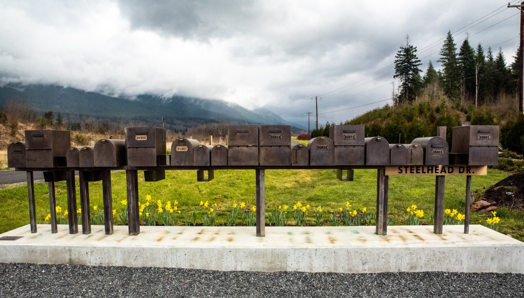
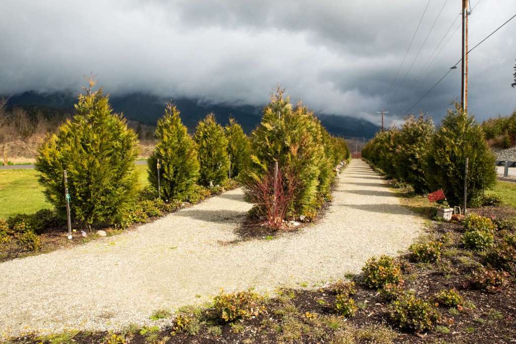
To the right of the gate, 43 cedar trees, one for each victim of the slide, were planted by family and friends. Each tree is decorated by a photo or something meaningful to the family members and the victim. Each tree has a small wooden plaque with the name of the victim it represents.

The parking space in front of the gate provides access to the Whitehorse Trail as well as the Oso Slide Memorial. The Whitehorse Trail runs on the historic rail bed of the Northern Pacific spur, known as the Whitehorse Express, that extended from Arlington to Darrington to transport logs and milled lumber. The trail parallels and sometimes crosses SR 530, offering a lovely walk or bicycle ride the length of the valley that holds the North Fork of the Stillaguamish River.


Fortson Mill
Several small communities once existed along the historic Whitehorse Express tracks. Only remnants can be found of those places now. Hazel, for example, once thrived near the modern site of the Oso Slide. The community had a post office, a school, and several homes. The geologic movement was called the Hazel Slide, but the only memory of Hazel now is a pond which was once the logging pond for the Hazel Mill.
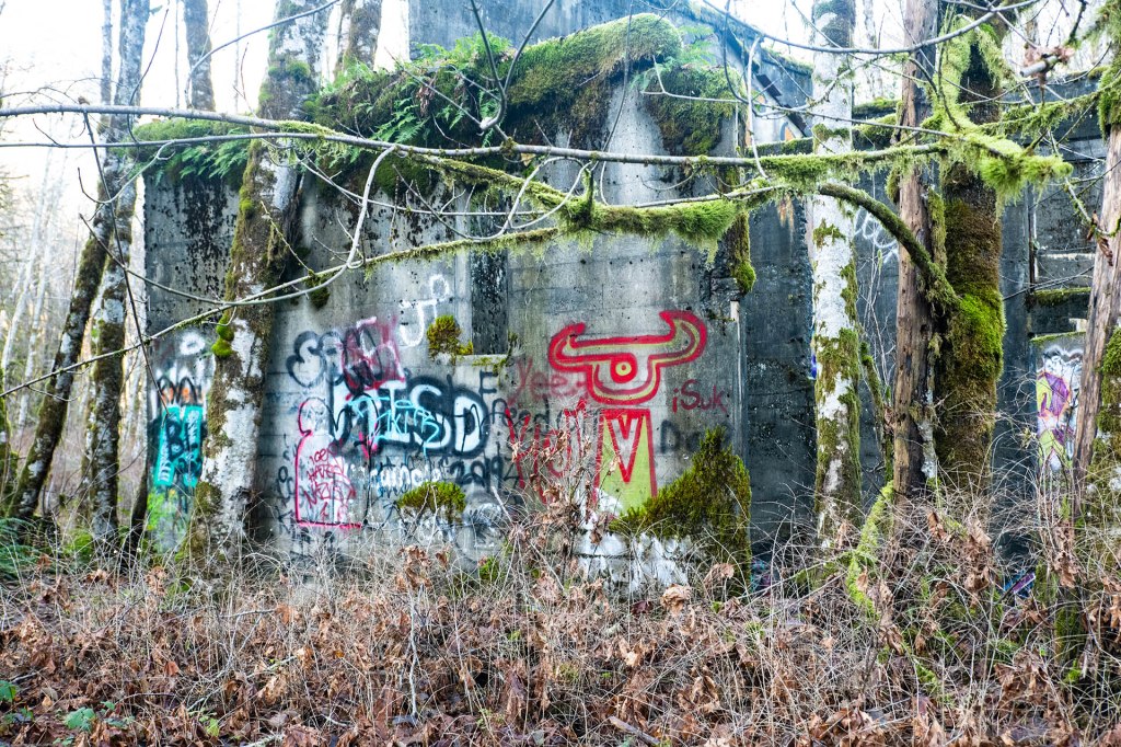
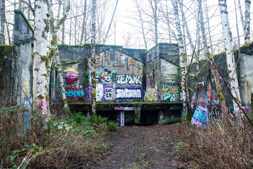
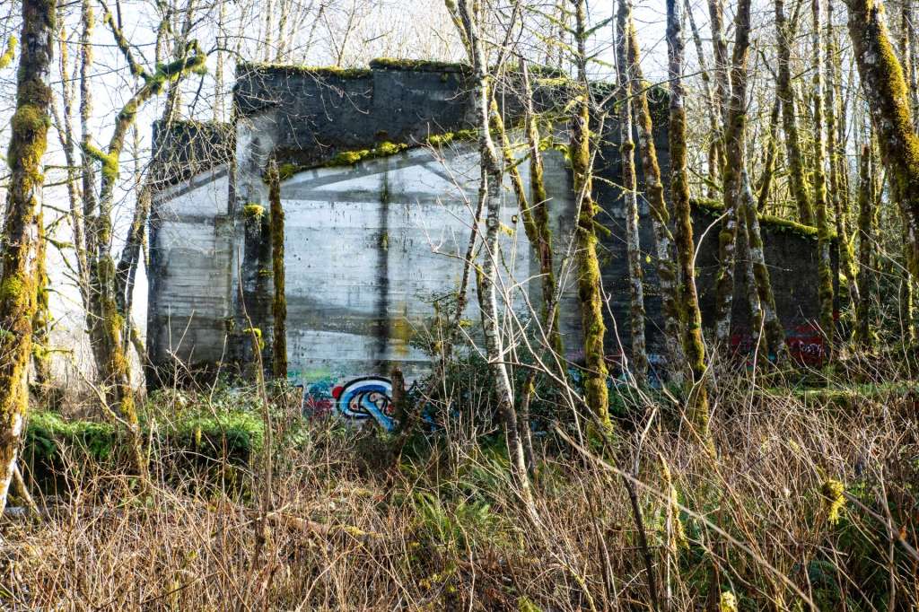
Farther east, the walls of the Fortson Mill are all that is left of the community of Fortson which was just north of the highway. Like other communities scattered along the valley of the North Fork of the Stillaguamish, Fortson began as a sawmill. In about 1914, the records are not clear, George Fortson, a Seattle attorney, bought the McCaughey mill and operated it until 1918. The mill was purchased in 1923 and renamed, but the town that had grown up around the mill retained the name Fortson. At the time the sawmill was reopened, Fortson had telephone service, a company store, post office, several nice homes, and three saloons, one of which was later converted into a school. Today, a visitor to Fortson Mill will find graffitied walls, a logging pond, and the Whitehorse Trail, vestige of the Whitehorse Express railroad that helped to build the community of Fortson.


East of Fortson Mill
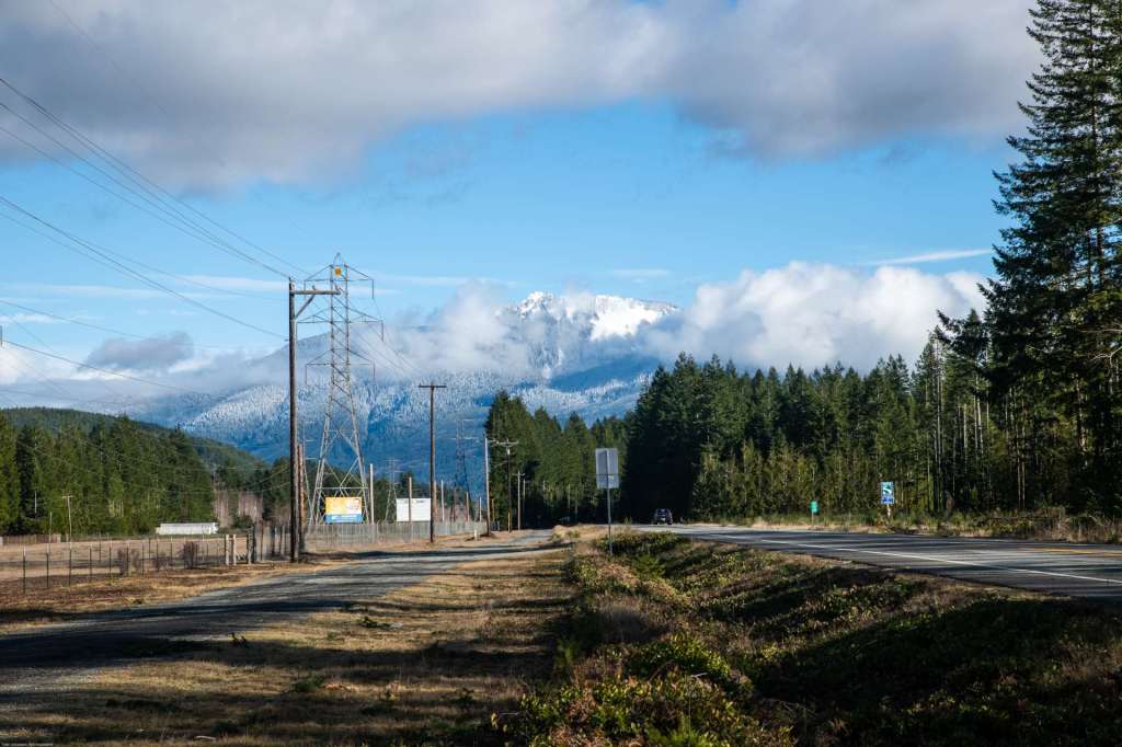
As SR 530 continues east, Whitehorse Mountain becomes more dominant on the horizon. Dairy farms flourish beneath the mountain. At Swede Heaven Road, a convenience store sits below the glacier-fronted mountain. Across the road, a weathered house looks out at the magnificent view behind the store.


Darrington Rodeo Grounds and Bluegrass Park
As SR 530 nears Darrington, the road passes the Darrington Rodeo Grounds and Bluegrass Park on the left.

Beyond the Rodeo Grounds and the Bluegrass Park, SR 530 enters Darrington. The last leg of the journey travels from Darrington to Rockport in the final post in this series, State Route 530 – Part 4.
All of the images and text in this post are copyright Tom Cochran Vagabond Photography. These and related images are available for purchase at Oso Washington and at Washington State Route 530. I hope you’ll enjoy this post and the others in this series.


1 reply »