This series of post describes a journey from northwest Washington state to East Wenatchee, along the central Columbia River to Umatilla, Oregon, west to Portland, north to Olympia, onward to Port Townsend, a ferry ride back to Whidbey Island, and home again. This was my first post-Covid-19 shutdown overnighter. The first step, from Everson to Everett, is at Cascades, Columbia, Capital, and Cannons – 1. The second post, Cascades, Columbia, Capital, and Cannons – 2, took us from Monroe, through several small towns along US 2 that were built by railroad, gold mining, and the timber industry, Sultan, Startup, Gold Bar, and Skykomish. This post will travel up and over the North Cascades at Stevens Pass, and down to Tumwater Canyon a few miles west of Leavenworth.
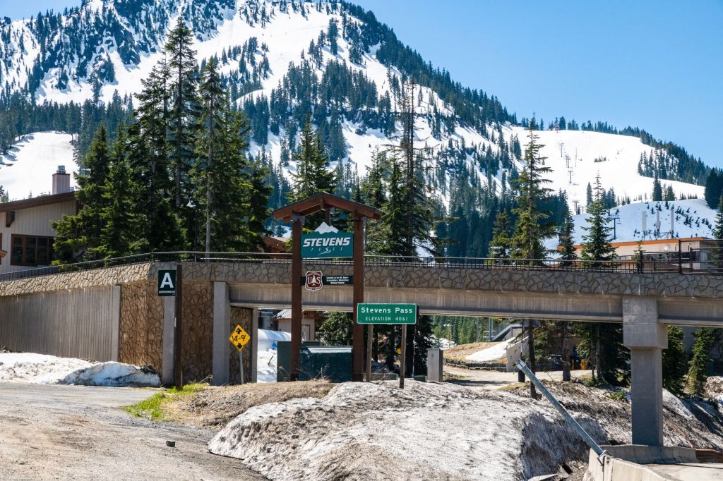
Stevens Pass
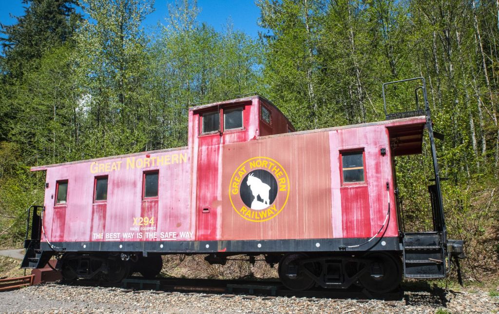
Great Northern Railway
US 2 passes beyond the small railroad town of Skykomish and climbs along the Skykomish River through firs and cedars. Deception Falls is on the right, though it’s tucked back among the trees and hills on the right and the driver must watch for it. Beyond the Falls, the Stevens Pass Highway passes the Iron Goat Interpretive Site. A faded caboose is parked at the site, a few miles west of Stevens Pass. The Iron Goat on the side is the logo of the Great Northern railway. Great Northern Railway laid the tracks over Stevens Pass that connected Seattle and St Paul. The midwestern United States were connected across the northern tier of states, Minnesota, the Dakotas, Montana, Idaho, Washington, all the way to Seattle on Puget Sound. Great Northern Railway merged with three other railroads to form Burlington Northern Railroad in 1970. Burlington Northern merged with the Atchison, Topeka, and Santa Fe Railway in 1996 to form the Burlington Northern and Santa Fe Railway, known as the BNSF. BNSF now owns and uses the route surveyed, engineered, and constructed by Great Northern. The interpretive site includes several fascinating posters with maps and history of the pass and railway.

A short distance up the road, the highway begins a steeper climb to the summit. The images on the left of each pair below were taken in September, 2015. The images on the right were taken in May, 2021, from as close to the same place as I could get, relying on my memory.

Climbing to Stevens Pass 
Same Place 6 years later

High Country Color 
Six Years Later
The first non-indigenous person to discover Stevens Pass was John F. Stevens. In 1890, Stevens surveyed the North Cascades seeking a route for the Great Northern Railway. James J. Hill, called the Empire Builder, hired Stevens to find a route west to extend Hill’s St Paul, Minnesota-based Great Northern to the west coast. Stevens had heard stories that the sources of the west-flowing Skykomish River and the east-flowing Nason Creek were close, suggesting a possible passage through the mountains. Though seldom visited and thick with forest and low shrubs, Stevens determined the pass was the best location for a railway to cross the Cascades.
Construction of tracks up and over the pass was started in 1892. The route from St. Paul to Seattle was completed in 1893, marked by a last rail spike pounded into a rail plate in Madison, Washington. Madison, later named Scenic, was 11.7 miles east of the town of Skykomish and 9.4 miles west of the community of Wellington. At the time, Madison apparently was little more than a water tower and depot. Wellington was the site of a tragic avalanche in 1910, described below.
Slopes were steep and dangerous, slides were common, compelling the construction of a series of switchbacks to climb the mountains on both sides. Trains could not make sharp turns, so a spur was added to the end of each section. A train would travel beyond the apex of the switchback to the end of the spur, then reverse to the next switchback, go beyond on that spur, and travel forward to the next switchback. There were three switchbacks on the eastern slope and five on the western slope. The original track route is in solid gray in the image below.

Cascade Tunnel
Heavy snows, avalanches, and other problems made the route impassable at times. It was decided a tunnel through the mountain was the only solution. Construction started in August, 1897 and was completed in December, 1900. The first tunnel, a line of dots above, was 2.63 miles long. John Frank Stevens was the principal engineer on the switchback track and, later, on the first tunnel. The two tunnels are collectively known as the Cascade Tunnel.
The tunnel was a success, avoiding some of the problems of the overland track for over nine years. Tragedy truck in March, 1910. A blizzard raged across the mountains during the last nine days of February, 1910. On February 28, the snow turned to rain. Two trains, a passenger and a mail train, both traveling east from Seattle, were stranded, blocked by the heavy snows, at the small community of Wellington, near the western tunnel mouth. On February 28, the snow turned to heavy rain. On March 1, 1910, rapidly melting snow resulted in a horrific avalanche. Most of the passengers and crew were sleeping on the trains. Both trains were swept downhill into the Tye river. The slide also crushed the depot. Ninety-six people were killed in the avalanche, including 35 passengers, 58 Great Northern employees on the two trains, and three more GN employees who were in the depot at the time. The community was renamed Tye because of the tragic association of the name Wellington with the disaster.
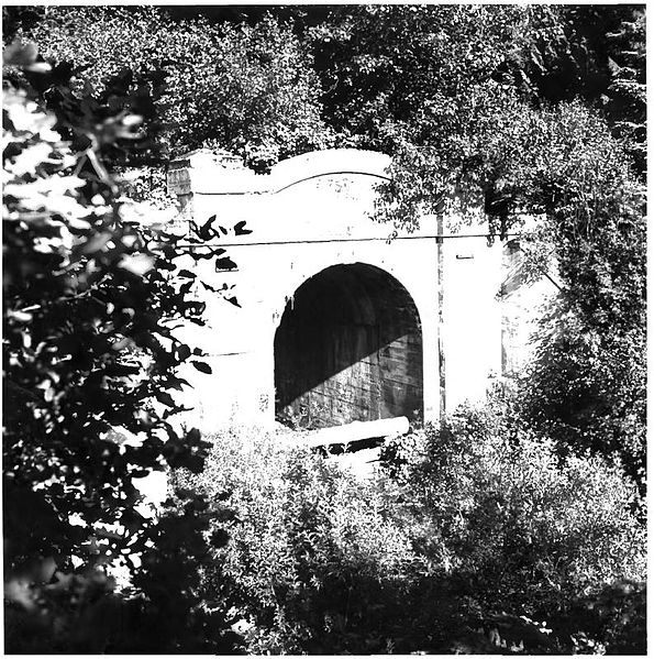
West Portal – Old Stevens Pass Tunnel 
Train Car and Debris After 1910 Avalanche
Snow sheds were built to protect the trains after the slide as temporary mitigation, but the disaster resulted in the construction of a second tunnel which began in December, 1925. The new tunnel was opened January 12, 1929. The new tunnel is 7.8 miles long, 5.2 miles longer than the older tunnel. It is also 500 feet lower than the first tunnel on the west end. The images below are of the east tunnel opening. The left image (an open commons image) looks directly into the tunnel. The red and white checkerboard structures in the mouth of the tunnel are doors that close after a train passes to enable the tunnel to be ventilated by powerful fans.

BNSF Cascade Tunnel, East Portal (Wikimedia Commons) 
Cascade Tunnel East Gate Facility
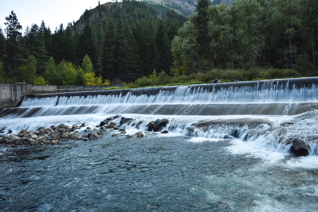
Both tunnels had serious ventilation problems as soon as they were completed. Coal-burning steam locomotives produced enough smoke to make breathing extremely difficult in the bore of the tunnel. The initial solution was to add four electric locomotives that pulled trains through the tunnel. The engines were 1500 hp General Electric boxcab engines powered by electrifying the tunnel. The electricity was provided by the Tumwater Hydroelectric Project that produced electricity at Tumwater Canyon Dam, a hydroelectric dam a few miles west of Leavenworth.
In the image on the left below, the Wenatchee River rolls over the Tumwater Canyon Dam on its way to greet the mighty Columbia River in Wenatchee. In 1909 when it was built, the dam was part of the largest hydroelectric project west of Niagara Falls.


“Tumwater” is an Indian word meaning “strong water”, or “falling water”. The “tum” part of the word is derived from “tumtum”, which means the “sound of a beating heart”, the sound of the rapids in Tumwater Canyon. The image on the right is a public domain post card. The caption reads, “Electric locomotive pulling the Oriental Limited, emerging from Cascade Tunnel on Great Northern Railway.” Electrification of the tunnel was discontinued in 1956, after large fans were installed for ventilation and Great Northern switched to diesel locomotives.
While Great Northern was transporting people and goods under the ground, the surface of Stevens Pass was being developed into a beautiful ski resort. Stevens Pass Ski Area was started in the winter of 1937-1938. The lodge was built in 1937, burned in 1939, and was rebuilt in 1940 by the Civilian Conservation Corps. The lodge was open when I visited in April, 2021, and the snow was still deep. Three feet or so on the roof of the lodge, twice the height of cars in the parking lots. Skiers and snowboarders were still swooshing down the runs.
The highway westward was hazardous to truckers going down the mountain curves. The bright yellow sign in the image below is at the summit, in front of a ski resort parking lot across US 2 from the lodge. The sign reads, ” Caution – Trucks: 6% Grade – 7 miles; 40 mph, 4 miles ahead.”


US 2 is a lovely scenic drive in the warm months. When the highway westbound down from the summit, or eastbound up to the summit, is icy or snow-covered, the twists in the road can be scary. On one side, the snow on the mountain is on the shoulder of the road, sometimes covering part of the outer lane of traffic. On the other side, snow-hidden Jersey barriers seem to be little protection if you start to slide towards the edge of the road bordered by a cliff that drops hundreds of feet.

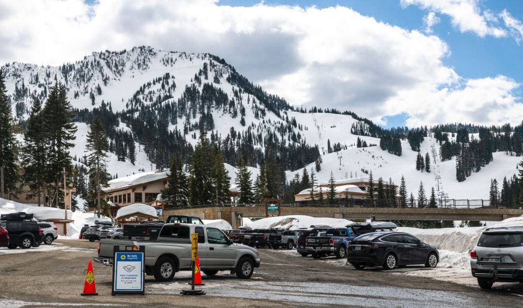
Snow plows carved the parking lots at the Stevens Pass Ski Resort, but the snow was still deep where the plows didn’t reach. In April, masks were still required everywhere, especially in the ski lodge at Stevens Pass. The blue and white sign, lower left, says, “Nose and mouth must be covered.”
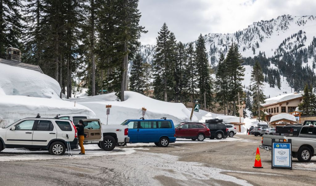
The snow was several feet deeper than the blue passenger van in the center.
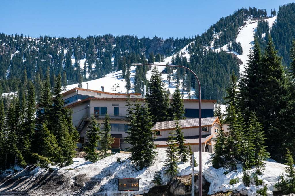
The two images of the Stevens Pass Ski Resort below were taken in May, 2021, after the snow had been melting for a while and the roofs were clear.

US 2 Downhill Towards Leavenworth
East of the pass, the highway slides downhill, down towards Leavenworth, the Christmas Town. Firs and cedars continue for a few miles from the summit on the east side, transitioning gradually to tall pines. From just east of the summit, US 2 parallels the winding Nason Creek down to Coles Corner. Nason Creek was followed up to the summit of the pass by John Stevens when he was surveying a route across the North Cascades for the Great Northern Railway.
Twenty miles down the mountain slopes from Stevens Pass, US 2 intersects SR 207. The intersection, called Coles Corner, is home to a diner, a gas station and convenience store, and several other small businesses. SR 207 heads northeast up into the mountains that cup Lake Wenatchee, the source of the Wenatchee River, and connects with the Chumstick Highway which passes through the small mountain community of Plain and back down to the east edge of Leavenworth.
Six miles south and east of Coles Corner, US 2 crosses the Wenatchee River, then parallels the Wenatchee as it travels through Tumwater Canyon on its way down to the Columbia. Small fishing boats and kayaks run the rapids in the Wenatchee River, down to the big, red warning sign above the Tumwater Canyon Dam, the hydro source of the electric locomotives that pulled trains through the Cascade Tunnels. The Tumwater Hydroelectric Project closed in 1956, after Great Northern switched from coal burning to diesel locomotives.

Leavenworth will be the next stop on this journey. I’ll visit Leavenworth, and continue on through Wenatchee to East Wenatchee in a post titled Cascades, Columbia, Capital, and Cannons – 4, the next post in this blog series. I hope you’ll join me.
All of the images in this post are copyrighted by me, unless otherwise indicated, and are available for purchase, as archival paper and canvas prints and household items like cups, blankets and shower curtains, by clicking on the images above or by going to US Highway 2 in Washington State. Thanks for visiting.
Sources
Oil-Electric – Last Spike, Great Northern Railway

2 replies »