Bridges cross from here to there. Over water, over train tracks, over land. This is a blog post about bridges. Wood and steel and concrete bridges. Bridges for people, bridges for vehicles. High, soaring bridges like the Astoria-Megler Bridge crossing the Columbia River, four miles wide at its mouth. Bridges crossing narrow creeks and rivers that can be leaped by one athletic jump, like the Grande Ronde River crossed by the Upper Perry Arch Bridge, a few miles north of La Grande, Oregon, in the image above. The Upper Perry Arch Bridge is a concrete deck arch bridge built in 1924 and rehabbed in 2008. It is 312 feet long and 19 feet wide. This bridge carries Old US 30, also known as the Hamilton Creek Frontage Road.
Bridges of all types, concrete, steel, and wood, can be found in the Pacific Northwest, and bridges tie this blog post together. This post describes a variety of bridges in the Pacific Northwest. It is a sample of the types of construction, size, and use of bridges in Washington state, Oregon, and Idaho. I like bridges, what they represent, what they do, how they bring people together. The beauty of function, the function of beauty.
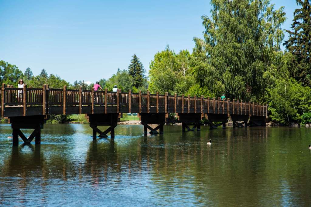
We start with a wooden trestle foot bridge that crosses the Deschutes River in Bend, in central Oregon. Bend is an outdoor city, offering cross-country and down hill skiing in the winter, hiking and cycling, like the folks in the image below, spring through fall, hunting and fishing year round. The 2017 population of Bend was 94,520.
A larger, higher bridge crosses the Snake River in Twin Falls, Idaho. The Perrine Bridge carries US 93 over the river, and has parking areas on both sides of US 93 north of the river and a visitors’ center west of US 93 on the south side. Agricultural runoff from southern Idaho farms colors the Snake olive drab.

If you want a leisurely ride down the river, you can kayak through the canyon, under the bridge, past Shoshone Falls at the east edge of Twin Falls and to the rapids at Auger Falls to the west. If heart-stopping adventure is more your style, you can jump off the Perrine Bridge, 486 feet above the river. Using a BASE jumper’s parachute is strongly recommended.
The Dalles Bridge makes a broad, sweeping curve as it leaves the Oregon shore before marching across the Columbia River, rising to meet the higher Washington shore. The Dalles Bridge, just downriver from The Dalles Dam, carries US 197 from Oregon to Washington. The City of The Dalles, population 13,620 in 2010, was once known as “the town at the end of the Oregon Trail.”

The Dalles Bridge stands about 14 miles downriver from the site of an ancient salmon fishing market, the Celilo Falls, or Wy-am in the local indigenous tongue, one of the longest continuously occupied sites on the continent. When The Dalles Dam went online, the resulting lake flooded Celilos Falls. The gracefully curving bridge was built in 1953. Due to problems in the construction of The Dalles Dam, the location of the bridge was moved downriver a short distance from its planned site, though the original design was retained.
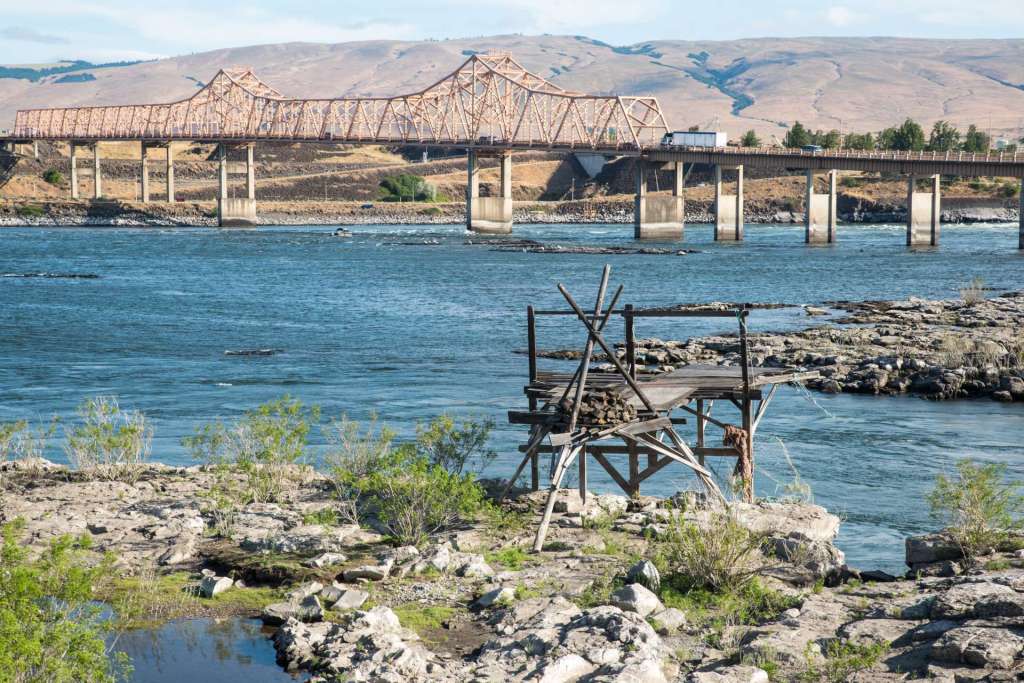
Celilo Falls disappeared in 1957, under the waters of the spreading Columbia River. Native fishing rights along the Columbia were preserved by treaties beginning in the 1850s and by Federal court decisions in the twentieth century following construction of dams along the Columbia. Fishing platforms and fishing villages near The Dalles Bridge and Dam maintain these historic treaty rights. Traditional fishing techniques and technology are still used.
Lewis and Clark called the fishing and trading area that stretched along the Columbia the Great Mart, where Native American tribes came to trade for salmon. As many as 5,00 people traded and feasted at the Great Mart for centuries. The Great Mart is now gone, sunk beneath the flooding waters, but it is still possible to buy salmon near the Native fishing camps.
Another traditional Native American fishing site in Washington state is bridged by the massive concrete Monroe Street Bridge in Spokane. The Spokane Falls, now the site of the Lower Falls Dam just upriver from the Monroe Street Bridge, welcomed Spokane and Nez Perce tribal members, as well as tribes from across the Columbia Plateau, to catch and trade for giant Chinook salmon.
This is the third bridge on this site in Spokane. The first, a rickety wooden bridge built for horses and wagons in 1889, burned in 1890.
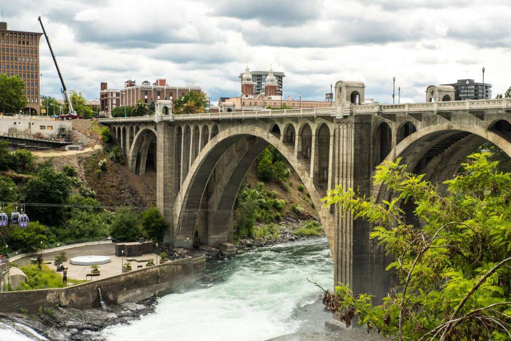
Monroe Street Bridge was built in 1911 and at the time was the largest concrete deck arch bridge in the US and the third largest in the world. Concrete bison skulls decorate the tops of the pillars. The twin domes of the Cathedral of Our Lady of Lourdes are beyond the center of the bridge. Dark clouds roof Spokane on the 2019 summer solstice.
The second bridge opened in 1892. That version was steel, but vibrated badly and had a dip in the middle. The steel bridge was labelled unsafe in 1905 by the National Good Roads Association. As proof of its instability, elephants with Ringling Brothers Circus refused to cross the bridge. Smart elephants! The south end of the bridge collapsed in a mudslide in 1910. The current concrete bridge opened in 1911 in a ceremony attended by 3,000 people, a very big deal at the time. The bridge was closed in 2003 for a major renovation and was reopened in 2005.
Some bridges are concrete, like the Monroe Street Bridge in Spokane, some are steel. The Dalles Bridge is a good example. Historic wooden bridges still serve in some places.
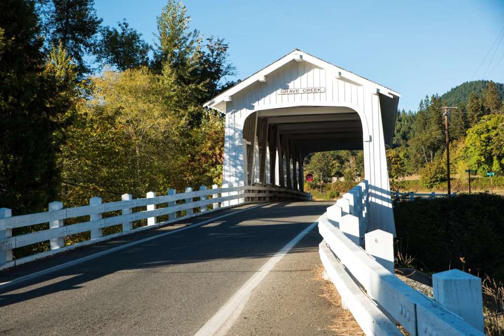
The Grave Creek Bridge in southern Oregon is one of 54 covered bridges in Oregon. Oregon has more covered bridges than any other state. Spanning Grave Creek, the bridge is a short distance east of I-5 on Sunny Valley Loop Road, 16 miles north of Grants Pass, Oregon. Built in 1920, the county took ownership of the bridge when I-5 was constructed. It was closed in 1990, and reopened in 2001 after repairs. Grave Creek Bridge has six Gothic windows on each side, concrete abutments, and a shake roof.
Two bridges cross the 4.1 mile long Chelan River near Chelan Dam in the City of Chelan, in central Washington. A footpath, the Chelan Riverwalk, circles the lake just above the dam, crossing on the two bridges. This bridge carries Woodin Avenue and is known as the old bridge. It is a concrete deck girder bridge. Built in 1927, it is the primary entrance to the City of Chelan from the south on Alternate US 97. Chelan had a population of 4,146 in 2017.
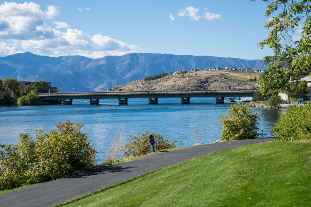
Lake Chelan Dam sits on a bluff above the Columbia River and impounds the 50 mile long Lake Chelan. The City of Chelan is on both sides of the Chelan River at the foot of the lake and two bridges cross the lake to join the city. The West Woodin Avenue Bridge, shown here, is farther from the dam. Chelan Lake widens above the Woodin Avenue Bridge as it begins its long stretch into the North Cascades mountains. The Rivewalk trail in the foreground follows the shoreline on both sides of the lake and crosses the lake on sidewalks across the Woodin Avenue Bridge and the Webster Avenue Bridge, behind the camera.
Concrete, Washington, on SR 20, 29 miles east of Burlington and I-5, had a population of 729 in 2017, big enough to have its own high school. The high school is noteworthy here because the school itself is a bridge. The school spans South Superior Avenue and provides shelter from rain and snow for students disembarking from school buses. Stairways on both sides of the road provide dry access to the school.
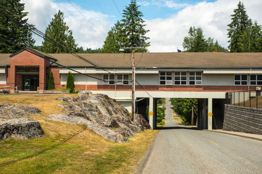
Concrete is a small town on State Route 20, half a mile to the north, on the road that passes under the school. Concrete is on the western slopes of the North Cascades, close to the Skagit River which is less than a mile behind the camera. In late June, no students can be found.
While the Concrete High School bridge spans only a two lane street, the Astoria-Megler Bridge takes four miles to cross the mighty Columbia River at Astoria, 14 miles from the mouth of the Columbia. The Astoria-Megler carries US 101 from Oregon to Washington, completing US 101, the Coast Highway, in 1966.
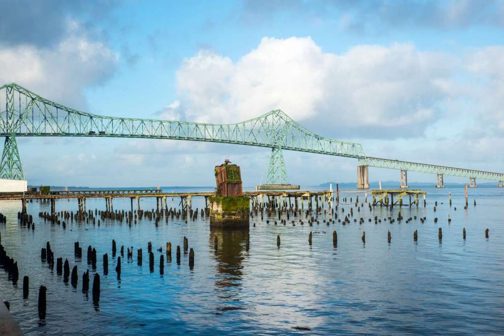
The highest span of Astoria-Megler Bridge flies 196 feet above the River at high tide. Weathered stubs of pilings and chunks of concrete and steel from long gone fish canneries speckle reflections of clouds on a calm morning in January as the sun climbs above Astoria.
The Astoria-Megler Bridge, at four miles in length, is the longest continuous truss bridge in North America. One lane of traffic north and one lane south serve vehicles every day but one. Once each year in October, the bridge is host to the Great Columbia Crossing, a walk/run race from Washington to Oregon on one lane, and vehicle traffic is restricted to one lane.
The small town (pop. 1,166 in 2017) of Cascade Locks, Oregon, was named for a set of locks that were constructed in to enable ships to bypass the Cascade Rapids in the Columbia River. The locks were built over a period of 18 years, between 1878 and 1896. The locks were submerged in 1938 by Bonneville Lake which was created by the construction of Bonneville Dam and replaced by Bonneville Locks that are connected with the dam. The historic Bridge of the Gods connects the city of Cascade Locks, a short distance downriver from Thunder Island, the location of Cascade Locks Marine Park, with State Route 14 on the Washington shore.
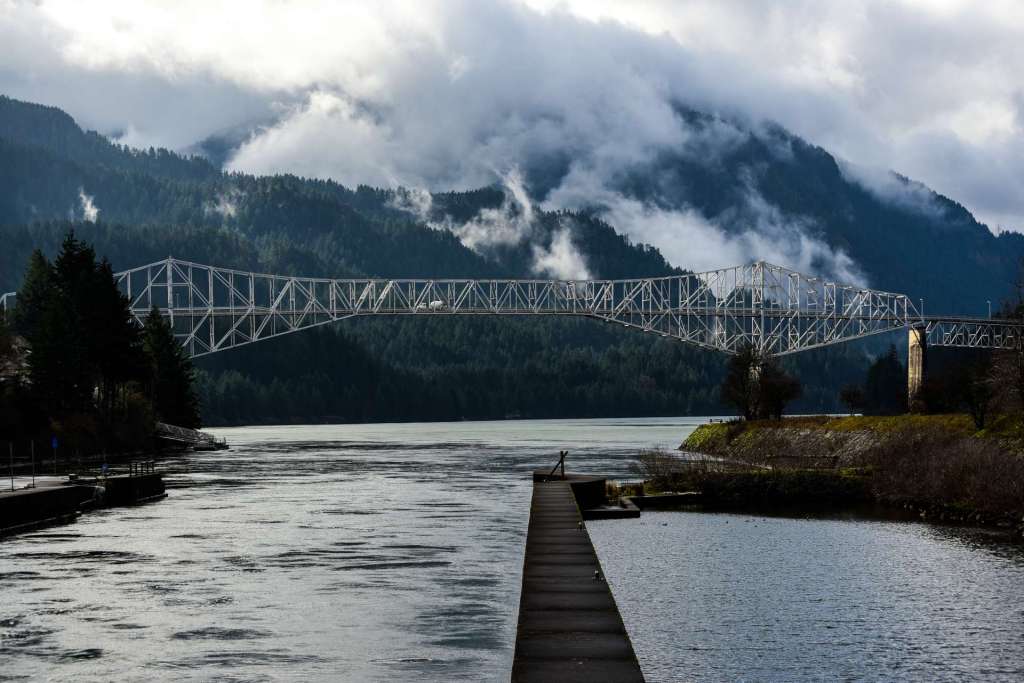
Rain-heavy clouds hang over Bridge of the Gods, between Cascade Locks, Oregon, and a location a short distance west of Stevenson, Washington. Oregon is on the left in this west looking shot. The concrete walkway in the middle is part of the original Cascade Locks. In February, clouds hang low over the Columbia River Gorge.
Between 1000 and 1700 years ago (various geologic studies indicate several possible dates), a massive landslide, known as the Bonneville landslide, poured north from Table Mountain and Greenleaf Peak, Oregon, across the Columbia River. The resulting pile of debris created a dam 3.5 miles long and 200 feet high that impounded a lake 35 miles long, submerging miles of forest. The dam provided a land bridge across the Columbia, remembered in Native American legend as a bridge created by the gods on which the river could be crossed in dry moccasins. Eventually, the Columbia eroded the rock and dirt dam, leaving the Cascade Rapids. The modern steel bridge was named after the dam and bridge created by the historic landslide.

The Bridge of the Gods today is a steel truss cantilever bridge, shiny and strong, supported by thick concrete pillars on and near each shore. It is a two lane bridge with a toll booth on the Oregon side. Bicycles, pedestrians, and horses are free, motorcycles are charged $1.00, passenger cars and pickups are charged $2.00, and larger vehicles and vehicles with trailers are charged more, based on the number of axles. One of the massive pillars on the Oregon side is decorated with murals of historic Columbia River events, including the passage of Lewis and Clark’s Corps of Discovery.

Bridges span rivers, lakes, highways, railroad tracks. Bridges connect people and places. Bridges reach across the years, connecting the past to the present, the present to the future. This post mentions just a handful of bridges in the Pacific Northwest. I’ll write about more in future posts.
If you have ideas for posts, suggestions, questions, or comments, please let me know. All images and text are copyrighted (C) Tom Cochran Photography.
Thanks for reading. Tom
Page break
Categories: Bridges