Semiahmoo First Nation
Travelers often go from one big city to another, and don’t have time to visit and explore the small towns, villages, and communities that are just off the highways. This is the first in a series of posts about Roadside Communities, the places that many folks call home, places off the highways, outside the big cities. This post visits Blaine, Washington, the Peace Arch City, gateway to the US from Canada.

Driving down the Interstate, it’s easy to miss charming, friendly, unusual, quirky smaller communities along the way. The first Roadside Community we visit after crossing the Canada border is Blaine, the Peace Arch City, with a population of 5,311 in 2017.


I-5 starts at Blaine, passing the shore of Semiahmoo Bay before the road runs through the US border crossing point. A traveler from Canada or returning to the US can stay on I-5, through Blaine and beyond. It’s easy to pass Blaine. But that means missing a delightful, charming community with a fascinating history.
A visit to Blaine needs several posts to touch on the history, people, and places. I’ll start in this post with the Semiahmoo, the indigenous people who are now a First Nations band just across the border. Then, I’ll talk about the industries that built Blaine, fish canneries and lumber mills. The twentieth century expansion of the community will be another topic. Finally, I’ll take a look at Blaine in the twenty-first century.
The Semiahmoo People. Before there was an international border, before the railroad and the boundary commission and the gold rush in the north, there were the mighty salmon swimming in the frigid waters of the north Pacific, fir and cedar covered hills, and the indigenous Semiahmoo people.
The Semiahmoo First Nations people, a small band of coast Salish people, lived on and near the northeastern shore of what is now Semiahmoo Bay, and around Drayton Harbor, and Boundary Bay, near what are now the communities of Blaine, Birch Bay, and Point Roberts, Washington, and Surrey and White Rock, BC. The Semiahmoo relied on salmon and wild roots, bulbs, and berries for food and used the ubiquitous red cedar for housing, tools, and even clothing. Canoes were made from large hollowed out cedar logs. They were distinguished from other northwest Indian peoples by using reef nets, instead of dip nets and portable traps, to catch the sockeye salmon that were returning to the Fraser River and its tributaries to spawn.

Before the Europeans arrived, the Semiahmoo lived in villages and summer camps scattered along the coast. Their principal village was on the end of the Semiahmoo Spit, where the resort now stands. The village had three rows of long houses, each 50 feet wide and 50 to 200 feet long. Two rows of houses faced west towards Semiahmoo Bay, and one faced east towards Drayton Harbor. By the time the Europeans first visited the area, the Semiahmoo had moved their village to the eastern shore of Drayton Harbor, near Dakota Creek.

By the early 1850s, the Semiahmoo moved again, this time to an area just north of Blaine, near the Campbell River. As a result, when the US Boundary Commission surveyed the 49th parallel in 1856, the Semiahmoo were living north of the US-Canada border, as residents of Canada. At that time, two towns, a small community on Semiahmoo Spit, and the community that became Blaine shared the name Semiahmoo.
The Semiahmoo First Nations band Reserve was created in 1887. The small area, 129 hectares or 319 acres, is situated along the crescent moon shore of Semiahmoo Bay, bounded by the city of White Rock, BC on the north and and northwest and by British Columbia Peace Arch Provincial Park on the east. The current Semiahmoo band population is 98, of whom 51 live on the First Nations Reserve land, and 47 live outside the Reserve land.
The Semiahmoo band has been diminished in numbers over the years, but there are ancient and recent, natural and human-crafted links to their history and importance to the North Coast.
The city of White Rock, BC, encompasses the Semiahmoo First Nations Reserve, though they are governed separately. White Rock takes its name from a large white rock on the beach below the city. The rock was deposited by glacial action during the last glacial period. For many years, it was kept white by the guano of shell-fish eating seabirds, and was used as a beacon by ships in the bay. More recently, it is painted white by City crews, though it is often the victim of graffiti. A Semiahmoo origin legend describes the reason for the existence of the rock at the western end of the Reserve.
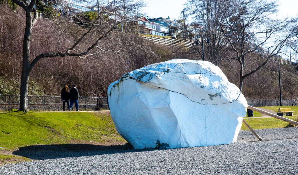
This story about the white rock is adapted from the oral histories of the Semiahmoo told by Grand Chief Bernard Charles and Bernard Charles Senior. The Legend of P’Quals (the white rock) tells that long before the European settlers came to the Salish Sea, the people were attuned with nature. A sea-being and his son protected the Salish Sea and the people who lived there.
One day, the daughter of the Cowichan chief was bathing in the sea when the sea-being’s son saw her and fell in love with her. Their parents did not approve, so the young man determined to take her away. He pulled a stone from the sea and threw it far over the water and said they would make their home where it landed. Taking his love in his arms, he swam after the rock as it grew to be a great boulder. It landed on the shore of Semiahmoo Bay, sixty miles away, where it became known as P’Qals.
More recent links to the history of the Semiahmoo people are totem poles on the shores of and near Semiahmoo Bay. One is the pole in the image below. The totem pole depicts the story of Raven and Salmon Woman. Carved in 1962 by Morrie Alexander, an internationally acclaimed carver and member of the Lummi tribe. The pole was originally displayed in front of the Semiahmoo Alaska Packers Association salmon cannery at the end of Semiahmoo Spit, across a narrow water gap from Blaine Pier. In 1981, the legend pole and three adjacent buildings were moved from the cannery to Semiahmoo Park where the Spit joins the mainland. The figures from top to bottom are Salmon Woman, Raven, Grizzly, and Thunderbird.

Raven married a woman who gave him salmon, so he called her Salmon Woman. He became wealthy because he had so many salmon. In time, Raven ignored Salmon Woman. When he did this, she ran away and disappeared into a fog. When she did, the salmon disappeared, too, but because salmon had been created, they returned each year.
A second totem pole, below, stands in Marine Park on the Blaine Pier. The pole was started by Phil Claymore, a marine biology teacher. Claymore died before completing the pole, but the last third was finished by his students in his memory. The pole was installed in Marine Park by the City of Blaine in August, 1995. The top figure is an eagle, and a raven is near the bottom, but I haven’t been able to find a description of the other figures on the pole.

I want to mention one more monument, a pair of poles that are not in Blaine, but are on the Semiahmoo Reserve in BC, a short distance west of the Blaine border crossing and the BC Peace Arch Provincial Park.
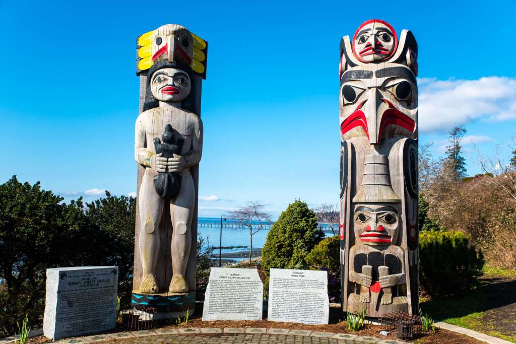
This description of Ka’Kan, the Coast Salish house post on the left, is drawn from a statement by Susan A. Point that is engraved on the granite stone immediately to the right of the house pole: “The raising of the housepost is of great spiritual significance within the Straits Salish beliefs and traditions of the Semiahmoo people. . . . On the base of this housepost, a water motif that has been adapted from a carving and weaving pattern that represents the Semiahmoo peninsula and the waters of Semiahmoo Bay.” Susan A. Point adds that the main figure, a man, represents protection, and on this pole represents the RCMP which commissioned the carvings. The man is holding a fisher and has an eagle on his head, both, symbols of power.
The Haida totem pole on the right, Gya Ana, is described on the granite stone immediately left of the totem pole in a statement by Terri-Lynn Williams-Davidson and Robert Davidson. “Watchmen are supernatural beings who serve as sentinels and caretakers and frequently appear on the tops of totem poles. The watchman [on the bottom, here] takes care of the community and visitors, and represents the Royal Canadian Mounted Police, placed at the community level. Above the watchman is the regal and powerful eagle which in this totem pole represents First Nations people. Above the eagle is the hawk moon crest, a raven crest, so that both principal clans of the Haida Nation are represented here.”
The stories of the Semiahmoo First Nations and their importance in the history of Blaine are part of the heritage of the people who live in Blaine now, people of a Roadside Community.
I hope you enjoyed reading a brief history of the Semiahmoo First Nations people who have lived in the Blaine, Washington, area for many generations. My next post about Blaine, a Roadside Community, will take a look at the canneries and lumber mills that are part of Blaine’s fascinating history and economy. See you soon.
Tom
All of the images and text in this blog post are mine, and are copyrighted. The images are for sale as paper and canvas prints and printed on various household items (like coffee cups, shower curtains, and blankets) at tomcochranvagabondphotography.com.
Categories: Roadside Communities, Washington State Journeys