In January, 2019, I road tripped down I-5 from home to Salem, Oregon, then over the Coastal Range to Newport on the Oregon Coast, and north on US 101 to Astoria. Part 1 of this series described a visit to Riverfront Park in Salem. Part 2 looked briefly at scenes in Newport. Part 3 enjoyed the trip up the Oregon Coast on 101. This last part of my journey looks at some of the things I saw and did in the lovely old city of Astoria, where the Columbia River meets the Pacific. Most of the images are from that January, 2019, journey, and I occasionally added images from previous trips.
I arrived in Astoria on US 101 in January, 2019, crossing the New Youngs Bay Bridge over Youngs Bay, which is the mouth of Youngs River. The bridge, completed in 1964 and 4200 feet long, replaced the Old Youngs River Bridge built in 1921. Driving north on US 101 from Cannon Beach, two routes are available to enter Astoria. The other route, which I followed on visits in 2015 and 2017, turns right onto SE Ensign Lane from US 101, between the Walmart and Costco stores. SE Ensign Lane becomes the Warrenton-Astoria Highway, aka Business (Bus) 101. Bus 101 turns north when it reaches the Lewis and Clark River, then crosses that river on the Lewis and Clark River Bridge, and turns north again to cross the Youngs River. After leaving the Youngs River, Bus 101 follows the northeast shore of the Youngs River until it reaches downtown Astoria. Lots of signs help visitors to find their goal.
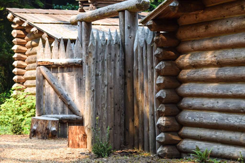
Before a traveler reaches the Lewis and Clark River, signs shows the way to Fort Clatsop, where Lewis and Clark spent the winter of 1805-1806.

Fort Clatsop is a fascinating place to visit, especially if a visitor is interested in the historical narrative of America’s exploration and settlement. A replica of the original fort was built in 1955, based on sketches in William Clark’s journals because the original has succumbed to the rain over the years. That first replica was destroyed by fire and the current, second replica was finished in 2006. The site is administered by the National Park Service. Staff in traditional dress, and maintaining the roles of period settlers, are available to answer questions and demonstrate the artifacts, such as furniture and tools.

I stayed at Astoria Crest Motel in January, 2019. The motel is on a bluff at the east end of Astoria on US 30, overlooking Astoria and the Columbia River. If you can make reservations, try to get a room on the river side, with great views of the River. The motel is reasonably priced. and comfortable. The Crest Motel has a meeting room, “designed by quilters so it has enhanced electrical and lighting systems which allow for everything you need to enjoy your groups time together.” A grassy area behind the motel offers a vantage point to see the Columbia and the east end of Astoria as it stretches east along the River.
Astoria, Oregon, had 9,862 people in 2017. Draped over Coxcomb Hill and overlooking the mouth of the mighty Columbia River, Astoria is just a few miles from the Pacific Ocean. The oldest American settlement west of the Rockies, Astoria was named after John Jacob Astor, New York fur trader. Fort Astor was built in 1811 to provide a trading center for the fur trappers that roamed the northwest. Surrounded by water on three sides and by tall fir, spruce, and hemlock trees, Astoria is a beautiful setting.

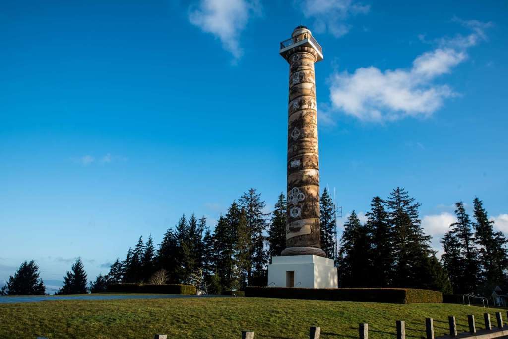
The next morning, I had a quick bite and drove to the Astoria Column, high atop Coxcomb Hill, overlooking Astoria, the Columbia River to the north, the Youngs and Lewis and Clark Rivers west of the city, the Astoria-Megler Bridge that connects Oregon and Washington, and, on the western horizon, the Pacific Ocean. Everyone who visits Astoria should take the time for a stop at the Astoria Column.

The observation platform at the top of the Column is a stiff climb, and I’ll write more about that in a moment. For folks who don’t want to climb to the top, the drive to the top of Coxcomb Hill is still worth the time. The drive up the winding road to the top is interesting, itself. It’s a narrow, two lane road, so watch for oncoming traffic as you go around the curves.
At the top, there’s plenty of parking. The parking spaces face out, so visitors can stay in their cars and still have an unobstructed view for miles in a broad arc from the northeast, past the north, northwest, west, southwest, south, and the southeast. In addition to the grand vistas, visitors will find restrooms and a gift shop at the parking lot. A Salish canoe worth a look and a photograph is at the west end of the parking lot is a memorial to Comcomly, a Chinook Chief.

The 125-foot tall Astoria Column was built and dedicated in 1926. The spiraling history of the exploration and settlement of the Astoria area moves upward from the indigenous Clatsop and Chinook cultures through significant events, from the arrival of Captain Gray in the Columbia Rediva in 1792 through the arrival of the Astoria and Columbia River Railroad in 1898. Only the first circle, identified as “Before the white people arrive” and resting on the base, depicts the many centuries of indigenous experience. Each of the 26 spirals above that genesis is about the “white people” in the area or about interactions between whites and indigenous peoples. Within the tower, a 164-step spiral steel staircase leads to an observation platform. Fortunately, there are three landings that allow for panting and puffing. When I made the claim, I stopped on each landing. A girl of perhaps 10 years, ran up the stairs past me. Then ran down. Then ran up again before I made it to the top. That made me aware that I’m not as young as I used to be.
I bought a small balsa wood airplane at the gift shop for $1.00 before I climbed to the top. These tiny aircraft are sold for would-be pilots to sail them from the platform at the top of the Column, though they can also be flown from the parking lot. Planes that land on the sweeping grassy hill below the column or on the parking lot are retrieved by staff. Successful flights land in the forests nearby. Yes, this is littering of a sort. However, the flimsy aircraft deteriorate quickly in the wet climate and return to the soil.
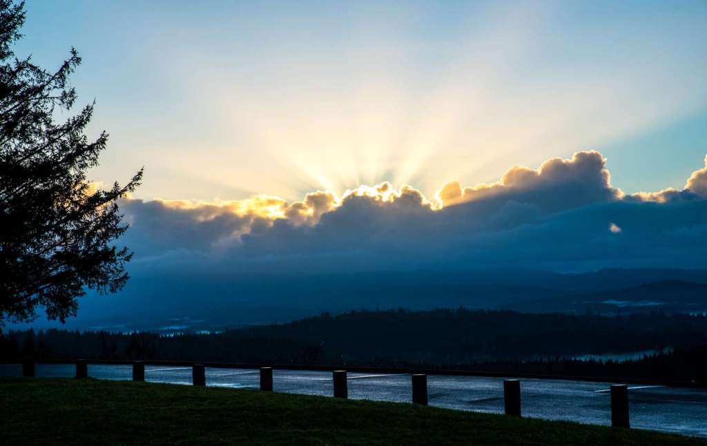
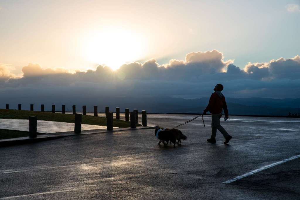
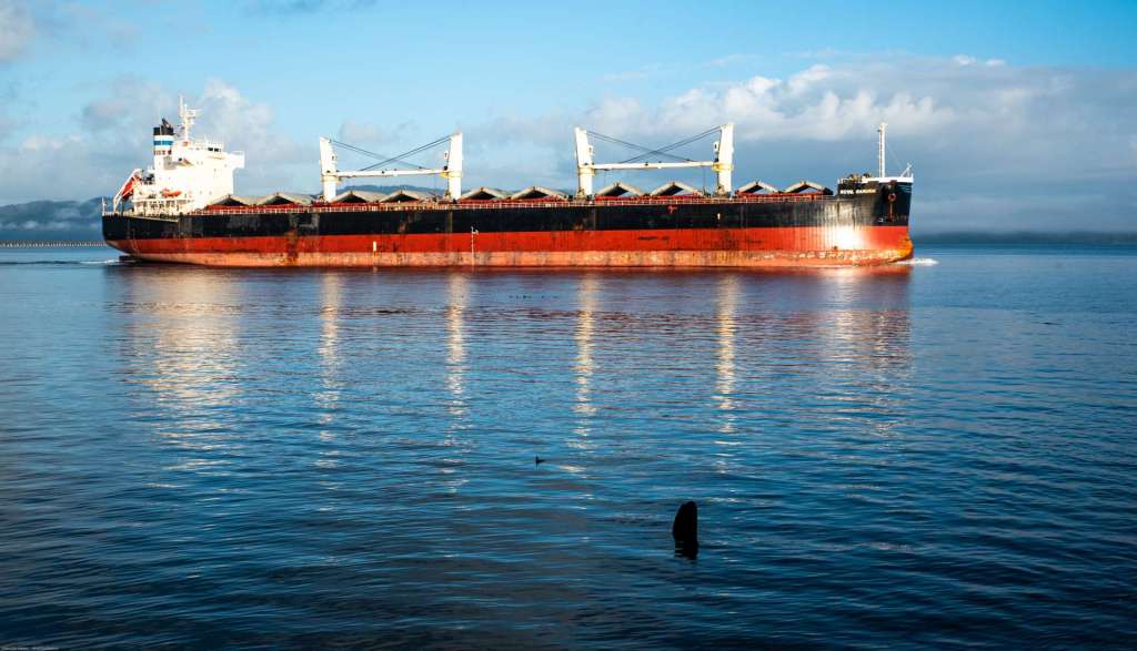
Sunrise at the Astoria Column is a beautiful sight, a wonderful way to start a day. Visitors admiring the Column. Astoria and the Astoria-Megler Bridge as the sun climbs above Coxcomb Hill. Youngs Bay southwest of town. Freighters steaming up the Columbia. These are some of the views I saw early in the morning from the platform at the top of the Astoria Column:


After welcoming the day atop the Astoria Column, I visited the Astoria waterfront. For visitors who haven’t had enough exercise climbing and descending the Column, a walk along the Astoria Riverwalk offers unparalleled views of the city and the river.
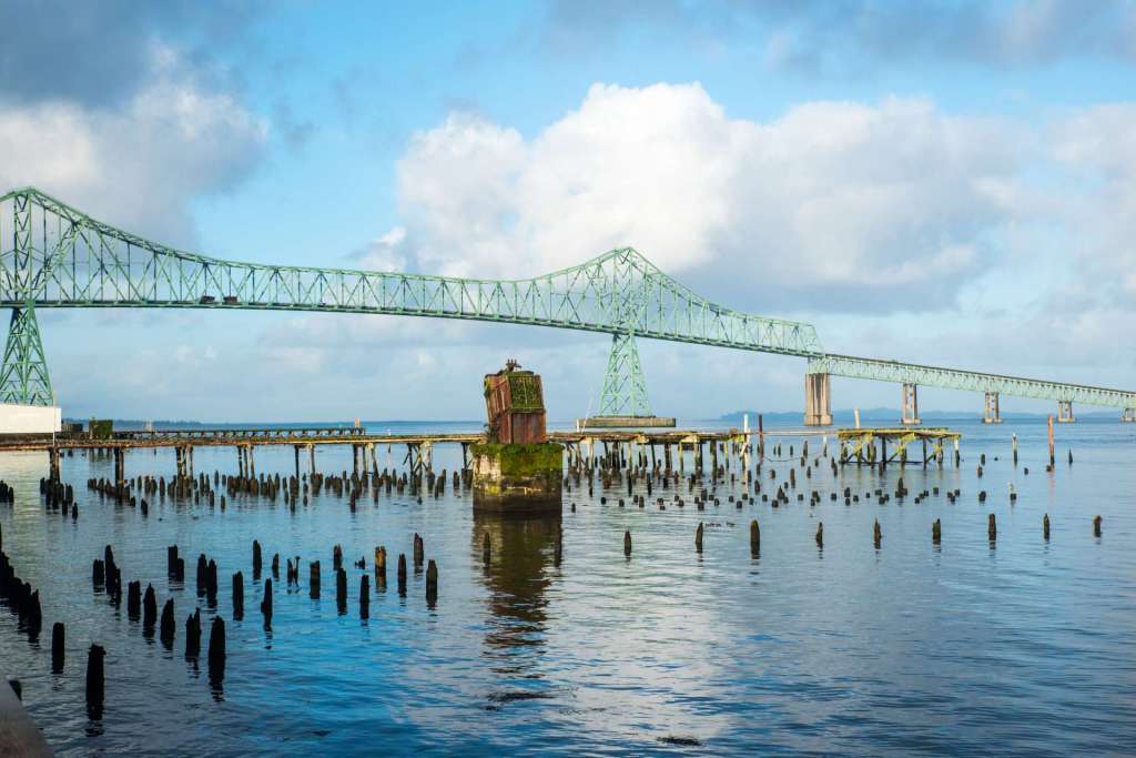
The Riverwalk begins west of the Astoria-Megler Bridge, at the far western end of town, and travels east along the Columbia to Lagoon Road at the base of the Tongue Point bluff.

The Columbia River Maritime Museum is next to the Riverwalk and the Trolley tracks. The museum offers fascinating exhibits that describe the forces at work along the Columbia River Bar, at the entrance to the Columbia River. Other exhibits on the U.S. Coast Guard and the Columbia River Bar Pilots give witness to legendary salmon fishing runs and a historic floating lighthouse, the lightship Columbia. The Museum is a private nonprofit museum supported by visitors and contributors like you. The Museum is not funded by tax dollars.”


The Lightship Columbia tour is included with your admission to the Columbia River Maritime Museum and is another remarkable piece of history. The Columbia served as a floating lighthouse, marking the approach to the treacherous Columbia River Bar, from 1951-1979. The Columbia is open for tours daily.
Pier 39 is a popular destination for visitors. A cedar plank roadway stretches out to the historic cannery buildings that have been repurposed as a museum, a hotel, a brew pub , a coffee shop, and other shops. There is limited parking at the end of the pier in front of the brewery and the canvas shop. If you don’t mind walking, you can park next to the Riverwalk and amble out. There’s room for the cars to pass the pedestrians, but be cautious with pets and children. The original Hanthorn Cannery is 143 years old.

If you don’t want to walk the whole shoreline, the Astoria Riverfront Trolley will carry you back in time and along the waterfront from the Riverwalk Inn to 39th Street at the east edge of town. The trolley is just $1.00 one way, $2.00 for all day. You can hop on almost anywhere along the track if you wave a dollar at the conductor.
The Riverwalk trail continues east to Tongue Point. Small houses are at the end of the Astoria exploration.
There are three ways to leave Astoria if a traveler is headed to northwest Washington. The least traveled route is across the Astoria-Megler Bridge, north on Washington SR 401 to SR 4, then east along the Washington shore of the Columbia to Longview, and then I-5 north. A popular alternative is to follow US 101 up the coast to the hard-working port of Aberdeen. Drive past the large loading cranes and cross the Chehalis River to pick up US 12 to Elma, then SR 8. US 101 follows the Pacific coast all the way up to the tip of the Olympic Peninsula, makes a button hook through Port Angeles and Port Townsend, Washington, on the Strait of Juan de Fuca, then drops south along Puget Sound to Olympia, the state capital. If the journey takes US 101 north from Astoria, the traveler will leave 101 at Aberdeen and pick up the tail end of 101 just outside of Olympia.
The most common road is US 30, which runs through Oregon, more or less in parallel with the Columbia, though it is frequently several miles from the river. The highway runs through hills verdant with fir and maple trees and past small farms carved out of the forest. The small town of Clatskanie, thirty miles east of Astoria, welcomes visitors to the farmers’ market in Cope’s Park on Saturdays and to the library Monday through Saturday.
Fourteen miles east of Clatskanie, take the SR 433 ramp up and over the Lewis and Clark Bridge, high above the Columbia River, to Longview, Washington. I-5 is on the east side of Kelso-Longview. I followed the Interstate home to northwest Washington.
This loop journey took four days. If you have time, take more time to visit the Oregon Capital and Riverfront Park in Salem, the shores of the Oregon Coast, and Astoria, at the mouth of the Columbia. The buttonhook loop of US 101, from Astoria to Port Townsend to Olympia will be another great trip. I’ll also write lots more in future posts about traveling the mighty Columbia.
If you’d like a print of any of the images in this series of posts, email me at tomcochran@cybermesa.com I’ll respond within a day or two to any questions, comments, or requests for prints. Thanks for reading.
All images are Copyright (C) Tom Cochran Photography.
Thanks for reading.
Tom
Categories: Oregon Journeys, Salem, OR