When I finished shooting the beach in front of Newport, I set out north on US 101 towards Astoria, at the mouth of the Columbia River.
The section of US 101, the Coast Highway, north of Newport passes through beautiful country. Heading north, the Pacific was on my left, the Northern Oregon Coast Range was on my right. Some stretches of the mostly two-lane highway are close enough to the shore line that waves pounding the sand can be seen from the road. In other areas, the roadway travels between tall pines or curves inland and runs through the foothills of the western Oregon mountains, winding in serpentine fashion through forests that feel primeval.
The coast can be accessed by roads that lead from the highway to the sand along the areas where hills separate the roadway from the shore. US 101 is the main street in several of the small town and communities along the coast, and in many of those communities, the shoreline is just a parking lot or one or two blocks from the highway.
A 1967 Oregon law, called the Beach Bill, granted permanent public access to the ocean shore from the line of existing vegetation to the sea, regardless of ownership. Oregon is the only west coast state that provides a public easement for the entire coastline along the state. Signs along 101 and in the towns direct travelers to the nearest beach access.
The northern section of the Coast highway is a convenient getaway for folks in Portland and Salem. Lincoln City, a beach town popular with out-of-state tourists and Oregonians, is less than two hours from Portland and just over one hour from Salem. A couple of miles north of Lincoln City on 101, take Oregon state highway 18 east toward Grand Ronde, a community of the Grand Ronde Confederated Tribes. Originally a reservation created by treaty between several bands of the Kalapuyan tribe and the Oregon Superintendent of Indian Affairs Joel Palmer in 1855, Grand Ronde became a company town owned by the Spaulding-Miami Lumber Company in the 1920s, and is now a residential center on the Grand Ronde Reservation.
Just beyond Grand Ronde, Highway 18 merges with Highway 22. About five miles farther east, 22 splits southeast towards Salem and 18 heads northeast towards Portland. All of the distances mentioned in my blog are approximate. I try to be as accurate as possible using Google maps and the odometer on my X-Terra, but Google . . .
An hour (44 miles) north of Lincoln City on 101 is Tillamook. Fishing and logging are important to the Tillamook economy, but the real draw for tourists, visitors, and the hungry and thirsty is the Tillamook Creamery, a farmer-owned co-op, home of sharp cheddar cheese, creamy ice cream, and refreshing, cheese curds, and wholesome milk. The visitors’ center at the Creamery is well worth a visit.
Tillamook, the cheese capital, is just an hour and twenty minutes from Portland and an hour and a half from Salem. Travelers to Salem from Tillamook will head 19 miles south on US 101 to Hebo, then southeast on Oregon highway 22, through Grand Ronde, and continue on 22 to Salem. Visitors traveling to Portland take Oregon state highway 6, the Wilson River Highway, on a winding two-lane road through the mountains to US 26, the Northwest Sunset Highway, east of Wilksboro, then southeast on 26 to downtown Portland.
The city of Tillamook sits at the southeast corner of Tillamook Bay. A short distance north of Tillamook, a wide shoulder on the east side of 101 offers a space to park and admire, and photograph Larson Cove, pictured below and Tillamook Bay across the highway.


Because the beach towns are relatively close to urban areas, the traffic on US 101, particularly as it passes through popular beach towns can be heavy at times. Visitors should also be wary of mudslides during heavy rains where 101 travels through the mountains that compel detours to and through the Willamette Valley.
Speaking of rain, Tillamook County and the City of Tillamook, the Dairylands city, are subject to serious riverine and coastal flooding when heavy rainfall is added to rapidly melting snow. Because of the possibility of flooding, visitors during winter and late spring should check ahead with local authorities for the conditions.
Garibaldi is a small fishing village on the north end of Tillamook Bay. US 101 curves around the eastern edge of the Bay and through Garibaldi, then turns right, north, along the coast.

Forty miles (about an hour) north of Tillamook on US 101, travelers will find Cannon Beach, Crescent Beach, Haystack Rock, and The Needles. Cannon Beach, a favorite destination for beach walkers, surf swimmers, and photographers, is a smidge over two hours to Salem, and only an hour and a half from Portland. The trip to Portland follows US 101, the Oregon Coast Highway, northeast four miles to US 26, then southeast to Portland.

Haystack Rock is a sea stack made of basalt formed by lava flows millions of years ago from the Columbia Plateau and the Blue Mountains in eastern Oregon. Once connected to the mainland, it is now separated by high tides. At low tides, visitors can walk out to the rock and look for tidal sea creatures such as anemones and star fish and terns, puffins and other sea birds that nest on the rock.

The needles, smaller rock formations near Haystack Rock, center right in the above image, are also basalt deposits from ancient times.
Spruce Street and Hemlock Street run north-south through Cannon Beach. Both streets end at 3d Street at the north end of town, near the Cannon Beach Christian Conference Center. To the north of the Conference Center, Public Coast Brewing welcomes visitors to Cannon Beach. Beyond the brew pub, Fir Street becomes North Alternate Route Highway 101. Drive across the bridge over Ecola Creek and turn left on East 5th Street. East 5th veers right and becomes Ecola State Park Road. Take the windy Ecola State Park Road at the top of bluffs to the State Park parking lot, less than a mile north. Ecola State Park is a definite destination for all visitors to the Oregon Coast.
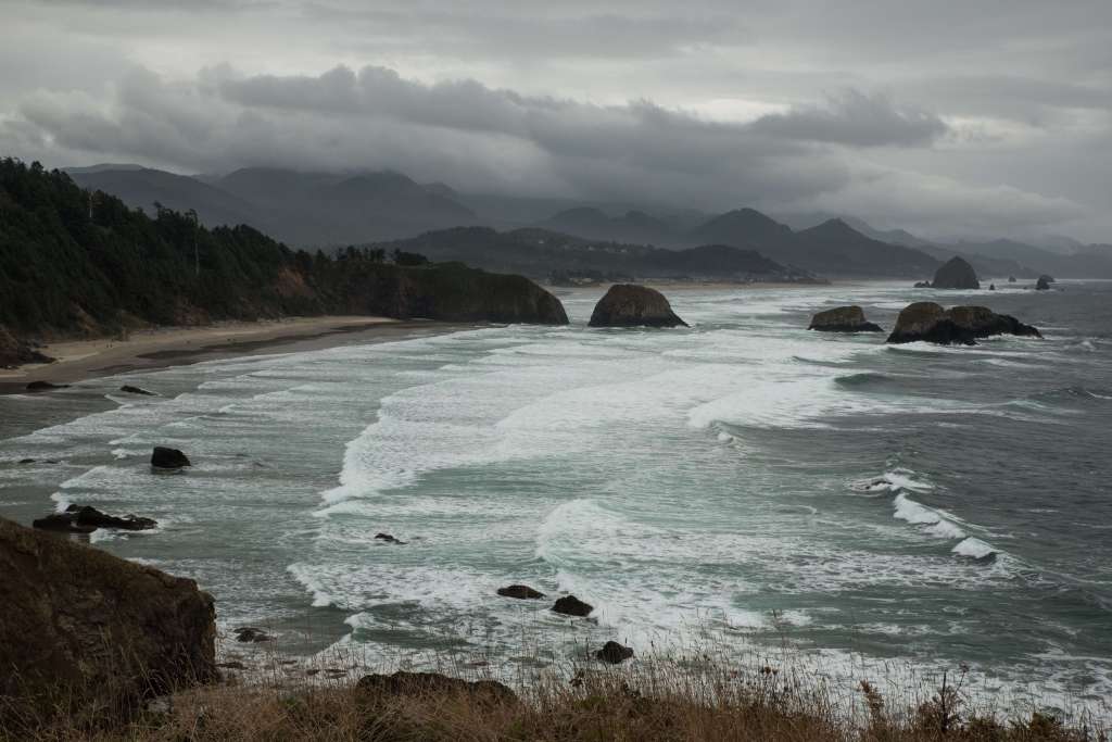
The view of Crescent Beach, far left in the above image, Cannon Beach, beyond Crescent Beach, and Haystack Rock, near the horizon above, is magnificent. Breakers roll in that are born far across the Pacific to pound the sandy beaches. The imperious mountains of the Coastal Range can be seen in the distance in the above image.

Ecola State Park is almost mandatory for photographers. Some shoot the coast, others shoot the steel gray sea on a stormy day. Some shoot the coast, the foaming breakers, the dark, stormy clouds, and other photographers.

Ecola State Park affords grand views of the sea, westering perhaps to Asia. A path leads from the parking lot to the edge of the bluffs, and down over the rocks for active climbers. This path, and the one that leads to the picnic table and favored photo shoot site, above, are smooth, and negotiable by mobility limited folks with assistance. Rest rooms are available at the parking lot.
The Ecola State Park Road continues a short distance north of the first parking lot to a parking lot for the Indian Beach Day-Use Area. Paths lead down the bluffs to the flat, sandy beach below. Indian Beach is beautiful location for walking dogs or exercising, but it is not accessible by limited mobility visitors. The beach and the rolling waves can be viewed from accessible paths near the parking lot.

When you are ready to leave, head back towards Cannon Beach on Ecola State Park Road to Alternate Route Highway 101, turn left, and merge back onto 101 northbound. US 101 travels inland for a few miles, then returns to the shore at Seaside, 14 miles north of Cannon Beach. 101 is the main north-south road through Seaside. Several miles north of Seaside, travelers can choose Oregon Highway 104 and visit Fort Stevens, a Civil War era fort intended to protect the mouth of the Columbia, in Fort Stevens State Park, and the wreck of the the Peter Iredale, a four-masted steel-plated barque that ran aground in 1906.
Although I continued on US 101 and crossed the New Youngs Bay Bridge into downtown Astoria in January, 2019, bypassing Fort Stevens and the Peter Iredale wreck, earlier journeys took me to Fort Clatsop. To visit Fort Clatsop, travelers northbound on 101 should turn right on SE Ensign Lane, between the Walmart south of Ensign and the Costco north of Ensign. Turn right on Fort Clatsop Road at the sign. If history interests you, this replica of the original wintering over Fort built by Lewis and Clark and the Corps of Discovery will be fascinating. Fort Clatsop and the Lewis and Clark National Historical Park are open every day but Christmas.

If you visit Fort Clatsop, return to Business US 101, the continuation of Ensign Lane, and turn right. Ensign, in the meantime, has sneakily become the Warrenton-Astoria Highway. Turn right and follow Business 101, the Warrenton-Astoria Highway, as it curves north and runs along the Lewis and Clark river and across the Lewis and Clark River Bridge, then north again to cross the Youngs River. It’s not as complicated as it might sound, for there are plenty of signs. Just stay on Business 101 into downtown Astoria.
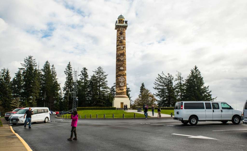
The image above is the iconic Astoria Column atop Coxcomb Hill. The Column offers a view of Astoria, the Columbia, and forested land to the east. I’ll write more about the Column and in my final post of this series, Journey to Salem – Part 4, Astoria. I hope you’re enjoying this vicarious visit as much as I enjoyed the multiple trips that went into making these memories, and the real pleasure it is to share these journeys with you. Please come back when you have time.
All of the images in this blog are mine, and can be found in the collections of my images at Tom Cochran Vagabond Photography. The images are all for sale as paper prints, canvases, and all sorts of unusual stuff, like shower curtains, coffee mugs, and towels. Even phone covers. Text and all images are copyright (C) Tom Cochran Photography, (C) Tom Cochran Vagabond Photography, and (C) Tom Cochran Vagabond Blog
Thanks. I hope you’ll comment.
Categories: Oregon Journeys, Salem, OR